Blog

Author: Banzai Japan

Wakayama Prefecture

The Prefectures of Japan Wakayama Prefecture

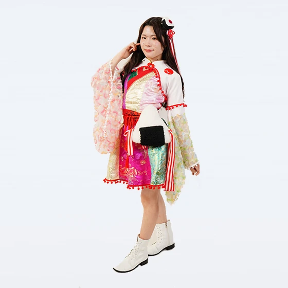
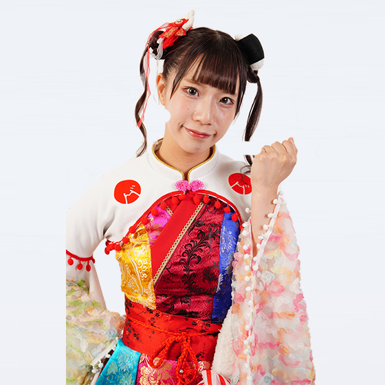
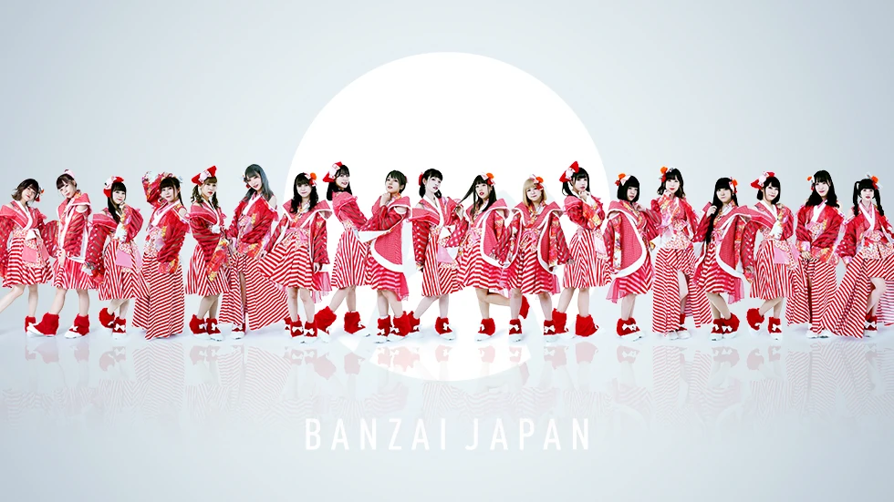
Wakayama Prefecture Banzai Japan Idol Group Visit there Website Wakayama Prefecture, on the Pacific coast south of Japan’s ancient capitals of Nara and Kyoto, has attracted pilgrims for centuries. Its Mount Kōya temple complex is one of Japan’s most sacred sites. Located in the Kii Peninsula in Kansai, Wakayama Prefecture is mostly covered by mountains, apart from a small plain around the capital Wakayama. The cape Shionomisaki is the southernmost point in the island of Honshū, looking out over the Pacific Ocean. To the west is the Kii Channel, linking the Pacific to the Seto Inland Sea. At 133 meters, Nachi Waterfall is Japan’s highest waterfall with a single, uninterrupted drop. Wakayama Prefecture at a Glance Established in 1871 (formerly Kii province) Capital: Wakayama Population: 923,000 (as of Oct. 2020) Area: 4,725 km2 The area that is now Wakayama Prefecture has attracted pilgrims for centuries. Mount Kōya in the northeast is a center for Buddhism, where Kūkai, one of the early proselytizers of the religion, established the Shingon sect in the ninth century. Many temples offer overnight stays to visitors. Meanwhile, Kumano in the southeast is known for its three major Shintō shrines connected by walking trails. A major fruit producer due to its warm climate, Wakayama is Japan’s top prefecture for growing mandarins, ume apricots, and persimmons. It is also number one for hassaku citrus fruits and sanshō or Japanese pepper. The mosquito coil was invented in the small city of Arida, which remains a leading manufacturer of the product today. Wakayama’s Kii-chan character is a Kishū dog—the name of the province where the prefecture stands today was Kii or Kishū. The mascot design incorporates a “W” for Wakayama. Famous Figures Minakata Kumagusu (1867–1941): A polymath who made contributions in the fields of biology, folklore studies, and environmentalism. Matsushita Kōnosuke (1894–1989): The founder of Matsushita Electric Industrial Company, which became a household name across the world as Panasonic. Maehata Hideko (1914–95): The first Japanese woman to win an Olympic gold medal, which came in the 200-meter breaststroke at Berlin in 1936. https://www.youtube.com/watch?v=-rjtcFddLxQ

Read More 🡥
Tottori Prefecture

The Prefectures of Japan Tottori Prefecture

Tottori Prefecture Banzai Japan Idol Group Visit there Website Tottori Prefecture is known for its sand dunes and as the home prefecture of the celebrated manga creator Mizuki Shigeru. Japan’s least populous prefecture, Tottori is in the Chūgoku region in the west of the island of Honshū. The country’s largest sand dunes can be found along its northern coast, beside the Sea of Japan. The Chūgoku Mountains stretch from east to west along the south of the prefecture, and much of the rest of its area is at a high altitude. Tottori Prefecture at a Glance Established in 1881 (formerly Inaba and Hōki provinces) Capital: Tottori Population: 553,000 (as of Oct. 2020) Area: 3,507 km2 Located within San’in Kaigan National Park, Tottori Prefecture’s 16-kilometer-long area of sand dunes in its capital of Tottori is the area’s best-known attraction. Visitors can climb a small hill for a view of the ocean. As the hometown of manga creator Mizuki Shigeru, the city of Sakaiminato has a museum dedicated to its famous son and many bronze statues of the yōkai (supernatural creatures) that appear in his works. Tottori is known for agricultural produce like rakkyō scallions and Nijisseiki nashi pears. It also has fine seafood, with notable catches of zuwaigani crab. In local crafts, there is inshū washi, a form of traditional Japanese paper. Toripy, the character for Tottori Prefecture, is a mixture of a bird (the kanji for “bird” appears in the prefecture’s name) and a Nijisseiki nashi pear, a famous local product. Famous Figures Mizuki Shigeru (1922–2015): Manga artist, best known for Ge Ge Ge no Kitarō, and other stories featuring supernatural yōkai. Otowa Nobuko (1924–1994): Actress, who appeared in many works directed by Shindō Kaneto, including the horror films Onibaba and Kuroneko. Ishiba Shigeru (1957–): Liberal Democratic Party politician, who has served as minister of defense and LDP secretary-general. https://www.youtube.com/watch?v=vjRjUz_SvCQ

Read More 🡥
Shimane Prefecture

The Prefectures of Japan Shimane Prefecture

Shimane Prefecture Banzai Japan Idol Group Visit there Website Shimane Prefecture has long been associated with Japanese deities, and Izumo Taisha is one of Japan’s most sacred Shintō shrines. Located in the southwest of the island of Honshū, Shimane Prefecture is in the region of Chūgoku, with the Sea of Japan to its north. The main population centers lie on the Izumo Plain in the northeast. The prefecture includes the volcanic Oki Islands, much of which are a national park. Shimane Prefecture at a Glance Established in 1881 (formerly Iwami, Izumo, and Oki provinces) Capital: Matsue Population: 671,000 (as of Oct. 2020) Area: 6,708 km2   The Izumo region of Shimane Prefecture has long been associated with Japanese deities, and Izumo Taisha is one of Japan’s most sacred Shintō shrines. Ōkuninushi, the legendary creator of Japan, is enshrined there. The capital city Matsue is known for Matsue Castle, a national treasure with architecture dating back 400 years. In the same city, Adachi Museum of Art is renowned for its outstanding garden. The historic Iwami Ginzan silver mine is a UNESCO World Heritage site. Lake Shinji in the northeast of Shimane Prefecture is associated with shijimi clams, for which the prefecture is the nation’s top producer. It is also notable for sea fishing and leads Japan in catches of conger eels. In traditional crafts, the prefecture is known for its Unshū abacuses; Unshū is another name for the province of Izumo. Shimanekko, the character for Shimane Prefecture, melds the prefecture’s name with neko, or “cat.” In a reference to the area’s importance in Shintō, the mascot’s hat evokes shrine architecture, and it wears a shimenawa, or sacred rope, around its neck. Famous Figures Mori Ōgai (1862–1922): Writer known for works including “Maihime” (trans. by Richard Bowring as “The Dancing Girl”), who was also an army surgeon and bureaucrat. Mori Hanae (1926–2022): Fashion pioneer, who was the first Asian to become an official member of the prestigious La Chambre Syndicale de la Couture Parisienne in Paris in 1977. Takeuchi Mariya (1955–): Best-selling city pop singer known for her song “Plastic Love,” which became a global hit via YouTube. https://www.youtube.com/watch?v=8tp25gweMJo

Read More 🡥
Okayama Prefecture

The Prefectures of Japan Okayama Prefecture

Okayama Prefecture Banzai Japan Idol Group Visit there Website Okayama Prefecture’s claims to fame include the venerated garden Kōrakuen, the well-preserved Bitchū Matsuyama Castle, and the popular folktale Momotarō. Okayama Prefecture is in the Chūgoku region in western Japan. It borders the Seto Inland Sea to the south and has numerous offshore islands. The inland is mostly mountainous, dominated by the Chūgoku range along the northern border with Tottori Prefecture, with large tracts of forested land. Okayama Prefecture at a Glance Established in 1871 (formerly Mimasaka, Bizen, and Bitchū provinces) Capital: Okayama Population: 1,888,000 (as of Oct. 2020) Area: 7,115 km2 Okayama is home to Kōrakuen, considered among Japan’s three most famous gardens, and Bitchū Matsuyama Castle, finished in 1683 and one of only a handful of fortresses retaining its original keep. Kurashiki in the south boasts a well-preserved historic district with elegant buildings and tree-lined canals. Large swaths of the prefecture fall within the borders of the sprawling Daisen-Oki and Setonaikai National Parks in the north and south, respectively. Okayama is home to one of Japan’s best-known folktales, the story of Momotarō, about a boy born from a peach who along with his animal companions defeats a group of menacing ogres. The prefecture has a robust agriculture sector, with farmers producing staple goods like rice and vegetables along with high-end items such as peaches, grapes, and wagyū-branded beef. Manufacturing is concentrated on the coast in cities like Okayama and Kurashiki, which have a number of large companies in core industries like petroleum, steel, and automobile production. The city of Kojima supports a thriving denim industry. Bizen ware pottery, lacquerware, and weaving remain important traditional industries in many areas. Okayama’s official mascots Momocchi and Uracchi are based on characters from the folktale Momotarō. Famous Figures Takehisa Yumeji (1884–1934): Painter and illustrator who was a leading member of the “Taishō Romanticism” art movement. Known particularly for his bijinga, depictions of beautiful women. Ōshima Nagisa (1932–2013): Film director and screenwriter known internationally for works like In the Realm of the Senses and Merry Christmas, Mr. Lawrence. Arimori Yūko (1966–): Marathoner and two-time Olympic medalist. https://www.youtube.com/watch?v=xZnqFEYdvVA

Read More 🡥
Hokkaidō Prefecture

The Prefectures of Japan Hiroshima Prefecture

Hiroshima Prefecture Banzai Japan Idol Group Visit there Website Hiroshima Prefecture is famed for its oysters, mikan, and sake, and is home to the Hiroshima Peace Memorial and Itsukushima Shintō Shrine. Hiroshima Prefecture is located at the southwestern end of the island of Honshū, in the Chūgoku region. It is largely mountainous, dominated by the Chūgoku range that runs along the northern border. The Seto Inland Sea forms the southern boundary of the prefecture and boasts numerous picturesque islands. Hiroshima Prefecture at a Glance Established in 1871 (formerly Bingo and Aki provinces) Capital: Hiroshima Population: 2,800,000 (as of Oct. 2020) Area: 8,479 km2 Hiroshima is home to two UNESCO World Heritage sites, the Hiroshima Peace Memorial commemorating the August 1945 atomic bombing of the city and Itsukushima Shintō Shrine, traditionally held to be one of the three most beautiful spots in Japan. The mountains to the north offer abundant hiking and other outdoor activities, and in the south scenic spots dot the coastline and islands of the Inland Sea. Manufacturing is a pillar of Hiroshima’s economy, including heavy industries like shipbuilding and automotives, along with pioneering sectors such as electronics. Hiroshima’s central location also makes it a domestic and international transportation hub. The prefecture is a major producer of mikan mandarins and other citrus fruits, as well as wagyū beef, and its succulent oysters feature on menus at restaurants around Japan. A major rice grower, Hiroshima is also famous for its sake. Hiroshima Kiyomori is the prefecture’s official tourism PR character. He is based on the military leader Taira no Kiyomori, who had deep connections with Itsukushima and other sites around Hiroshima. Famous Figures Ibuse Masuji (1898–1993): Novelist, poet, and essayist. Author of the short story “Sanshōuo” (tr. by John Bester as “Salamander”) and the novel Kuroi ame (tr. by Bester as Black Rain) recounting the atomic bombing of Hiroshima. Maruki Iri (1901–1995): Artist and hibakusha who with his wife Toshi (1912–2000) created “The Hiroshima Panels.” Oda Mikio (1905–1998): Athlete and the first Japanese Olympic gold medalist. Won the triple jump event at the 1928 Summer Olympics in Amsterdam. https://www.youtube.com/watch?v=XHOmBV4js_E

Read More 🡥
Yamagata Prefecture

The Prefectures of Japan Yamagata Prefecture

Yamagata Prefecture Prefecture Banzai Japan Idol Group Visit there Website Snowy Yamagata Prefecture, in Japan’s Tōhoku region, is home to the Dewa Sanzan, three sacred mountains forming the core of one of the oldest religious traditions in the country. Yamagata Prefecture, on the Sea of Japan coast in the Tōhoku region, lies south of Akita, west of Miyagi, and north of Niigata and Fukushima. The ninth largest prefecture by area but just the thirty-fifth by population, it is a sparsely populated place featuring rugged mountains including the Dewa Sanzan, three peaks held to be sacred spots for practitioners of Shugendō, one of Japan’s oldest native religious traditions. Yamagata Prefecture at a Glance Established in 1876 (formerly part of Dewa province) Capital: Yamagata Population: 1,068,000 (as of Oct. 2020) Area: 9,323 km2 The inland city of Yamagata, the largest in the prefecture, has just short of 250,000 residents calling it home. Tsuruoka and Sakata, on the northern coast, and Yonezawa in the south follow the capital in the population rankings, but Yamagata Prefecture as a whole is largely rural. Fully 17% of the prefectural area falls inside of natural parks, and the eastern border of Yamagata runs along the Ōu Mountains, the longest range in Japan. In the far north of the prefecture is Mount Chōkai, its highest point at 2,236 meters in elevation. The prefectural center, meanwhile, is the site of the northern Echigo Mountains, including Mount Gassan (1,984 meters), Mount Yudono (1,504 meters), and Mount Haguro (414 meters). These are the Dewa Sanzan, the “three peaks of Dewa” where Shugendō retains a strong hold. These mountains are also cherished by the relatively newer arrival of Buddhism; the Yamadera (“mountain temple”) complex of several dozen structures, formally named Hōjusan Risshakuji, was founded in 860 by Jikaku Daishi (794–864), then the head of Japan’s Tendai school of Buddhism. An esoteric sect of the faith also produced the tradition of sokushinbutsu, in which monks committed themselves to mummification while still alive, seen most frequently in the temples of Yamagata. The prefecture’s economy depends heavily on modern industries like communications and electronics devices and chemical products, building on a mining tradition that led also to a strong metal-casting industry from medieval times onward. Yamagata remains known for its agriculture as well, though, in particular cherries (the prefecture grows around 70% of the national total) and Yonezawa wagyū beef, one of the top local appellations in Japan. The area became much more accessible from Japan’s main population centers in 1992, when the Yamagata Shinkansen was opened as far as the prefectural capital; in 1999 the line was extended as far as Shinjō in Yamagata’s north. This spur line parts from the main Tōhoku Shinkansen route at Fukushima Station to bring passengers across the spine of Honshū to the island’s west. Kitekero-kun, the Yamagata prefectural mascot, has a name that means “Please come on up!” in the local dialect of Japanese. Kitekero-kun has a face shaped like Yamagata and wears a hat decorated with the prefecture’s famed cherries. Famous Figures Ogata Taketora (1888–1956): Journalist and politician. Was the chief editor of the Tokyo Asahi Shimbun in the prewar and early wartime era, as well as vice president of the newspaper publisher; turned to politics thereafter, serving in the cabinets of Koiso Kuniaki (1944–45) and Higashikuni Naruhiko (1945). Was purged from politics under the Allied Occupation but returned to serve in the cabinet of Prime Minister Yoshida Shigeru in 1952–53. Inoue Hisashi (1934–2010): Writer. Established his fame as a playwright, launching his own theater troupe, the Komatsuza, in 1983, but was also an accomplished novelist, winning the Naoki Prize in 1972 for Tegusari shinjū(Handcuffed Double Suicide) and both the Yomiuri Prize for Literature and the Japan Science Fiction Grand Prize in 1981 for Kirikiri-jin (The People of Kirikiri). Katō Kōichi (1939–2016): Politician. Born in Aichi, Katō grew up in Yamagata and represented the prefecture in the Diet for most of the period from 1972 to 2012. In 2000, following the death of Prime Minister Obuchi Keizō, launched “Katō’s rebellion” against the caretaker prime minister, Mori Yoshirō, but was driven from the political sphere for a time after its failure. https://www.youtube.com/watch?v=dYxK4SPZKOE

Read More 🡥
Kōchi Prefecture

The Prefectures of Japan Kōchi Prefecture

Kōchi Prefecture Banzai Japan Idol Group Visit there Website Kōchi, the largest of the four prefectures on the island of Shikoku, is famed for its natural splendor, including the pristine Shimanto River. Kōchi is the largest of Shikoku’s four prefectures. Its arching southern coastline borders Tosa Bay and the Pacific Ocean, while the inland is largely mountainous and densely forested. Much of the population resides in the centrally situated Tosa plain, where the prefectural capital of Kōchi is situated. Kōchi Prefecture at a Glance Established in 1871 (formerly Tosa province) Capital: Kōchi Population: 692,000 (as of Oct. 2020) Area: 7,103 km2 Kōchi offers visitors many tourist attractions. Its long coastline is marked by picturesque headlands, beaches, and other natural features. In the mountains, the sprawling Tengunomori plateau along the border with Ehime Prefecture is dominated by the Shikoku Karst, and the Shimanto River, considered Japan’s last pristine waterway, flows in the southwest of the prefecture. Kōchi is home to several temples on the henro pilgrimage route around Shikoku, and Kōchi Castle and Hirome Market, with its shops offering katsuo tataki (seared bonito) and other local delicacies, are popular stops in the capital. Kōchi’s agricultural, forestry, and fishing industries account for a large portion of its economic output. It is a major producer of yuzu, or Japanese citron, the scent of which is used to enhance the aroma of an array of items from bathwater to foods. The prefecture is also known for its abundant hauls of bonito, traditionally caught with just a pole and line in a style called ipponzuri, along with a range of other marine products brought by the Kuroshio (Japan Current) that flows along its coast. Other important sectors include the manufacturing of industrial machinery, paper, and lumber. Traditional manufacturing includes washi (Japanese paper), forged blades called Tosa uchihamono, and ceramics. Kuroshio-kun, Kōchi’s official mascot, brings to mind the waves of the Japan Current (Kuroshio), which flows off the prefecture’s Pacific coastline. Famous Figures Nakahama Manjirō (1827–98): Also known as John Manjirō, he was rescued by an American whaling ship when his fishing boat went adrift and ended up travelling to the United States, where he studied English and other subjects. Served as a translator and interpreter for the Japanese government. Sakamoto Ryōma (1836–67): Imperial loyalist known for brokering an alliance between the Satsuma and Chōshū domains (now Kagoshima and Yamaguchi Prefectures, respectively) that brought an end to the Tokugawa shogunate. He was famously assassinated by unknown figures while in Kyoto. https://www.youtube.com/watch?v=m3d0HbNAB5w

Read More 🡥

Newsletter

Subscribe to our newsletter for update informations, recipes or insight

Latest Post